Extreme Conditions Across the Caribbean and Southeast US! Floods, Dust, and Potential Storms
The natural world is currently presenting a formidable and multifaceted challenge to the residents of the Caribbean and the Southeastern United States, as a series of disparate environmental threats converge in a rare and volatile display of atmospheric and geological power. In a window of time that has caught the attention of the global meteorological community, the region is grappling with a staggering array of phenomena: seismic shifts in the earth, torrential floods, choking dust storms from across the Atlantic, and the looming specter of intensifying tropical cyclones. This unprecedented synchronicity of events has moved beyond a mere weather forecast, evolving into a complex crisis that demands a heightened state of vigilance and a sophisticated approach to emergency preparedness.
At the heart of this unfolding situation is a sense of geographic vulnerability that spans thousands of miles. In the southern reaches of the Caribbean, the ground itself has offered a stark reminder of the region’s instability. A significant earthquake recently struck near the island of Trinidad, sending shockwaves through local communities and leaving residents in a state of nervous anticipation. While the immediate structural damage is being assessed, the primary concern for emergency planners remains the threat of powerful aftershocks, which can often be more destructive than the initial quake if they strike already weakened infrastructure. This seismic activity occurred just as Central America was already reeling from catastrophic flooding. Weeks of relentless rain have turned streets into rivers, displaced thousands of families, and overwhelmed the capacity of local emergency services. The saturation of the soil in these areas means that even a moderate rainfall now carries the risk of deadly mudslides, creating a precarious environment where the margin for safety is razor-thin.
As if the threats from the earth and the rain were not enough, a massive plume of Saharan dust has crossed the Atlantic, casting a hazy, orange pallor over the islands. This meteorological phenomenon, while not uncommon, has reached a scale that is triggering urgent air quality alerts from Puerto Rico to Jamaica. For those with respiratory vulnerabilities, such as asthma or chronic obstructive pulmonary disease, the fine particulate matter carried within these dust clouds represents a direct and immediate health risk. Visibility has dropped significantly in affected areas, complicating air travel and maritime navigation, and adding a layer of atmospheric tension to a region already braced for disaster. The dust acts as a gritty reminder of the interconnectedness of global weather systems, showing how a storm in the African desert can impact the daily lives of residents in the Caribbean basin.
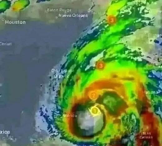
However, the most significant and rapidly evolving threat comes from the Atlantic’s tropical waters. Meteorologists are focusing their intense scrutiny on Tropical Storm Flossie, a system that has begun to exhibit signs of rapid intensification. Fueled by unseasonably warm sea surface temperatures, Flossie is expected to grow in both strength and size as it tracks toward more populated coastlines. But Flossie is not a solitary actor; additional tropical disturbances are currently brewing in the Atlantic, some with projected trajectories that point directly toward the Southeastern United States. States like Florida and Georgia, which have long histories of dealing with the fury of hurricane season, are once again under the microscope. The potential impacts of these combined systems are vast and varied, including the threat of life-threatening coastal storm surges, devastating flash floods from extreme rainfall, and high-velocity winds capable of toppling power grids and leveling structures.
What makes the current moment so uniquely dangerous is the concept of “compounding disasters.” In a standard emergency scenario, resources are funneled toward a single event—a hurricane, for example, or a localized flood. However, when these events occur simultaneously or in rapid succession, the strain on human and technical infrastructure is multiplied. Emergency response teams that are currently managing flood relief in one area may find themselves redirected to handle earthquake recovery in another, or hindered by the low visibility of a dust storm while attempting to evacuate coastal residents ahead of a tropical cyclone. This convergence creates a “volatile synergy,” where the cumulative effect of the disasters far exceeds the impact of any single event. Experts warn that this overlap can lead to significant delays in communication and rescue efforts, making it essential for individuals to take personal responsibility for their safety before the worst conditions arrive.
In the face of such overwhelming natural force, the call for proactive preparation has never been more urgent. Emergency management agencies are emphasizing that the time for theoretical planning has passed; the current conditions require decisive action. For residents in the path of these various threats, the first line of defense is information. Monitoring trusted, real-time weather sources is critical, as the track and intensity of tropical systems like Flossie can shift in a matter of hours. Beyond staying informed, the physical reality of a “go-bag” has become a literal lifesaver. These kits, containing at least a three-day supply of water, essential medications, copies of vital personal documents, and non-perishable food, are the difference between a controlled evacuation and a chaotic flight. In flood-prone regions, knowing multiple evacuation routes is vital, as primary roads are often the first to be submerged or blocked by debris.
The humanitarian aspect of this convergence cannot be overlooked. Natural disasters have a disproportionate impact on the most vulnerable members of society, particularly the elderly, those with limited mobility, and families living in substandard housing. Community resilience is built on the strength of neighborly bonds. Checking in on those who may not have access to digital alerts or who lack the physical means to board up their homes is a crucial component of a comprehensive safety strategy. During the periods of heavy dust, the advice remains clear: limit outdoor physical activity and ensure that indoor air filtration systems are functioning. For those in the direct path of the brewing storms, the message is one of immediate readiness—securing loose outdoor items, reinforcing windows, and ensuring that vehicles are fueled and ready for travel.
Nature is currently delivering a powerful and unavoidable warning to the Caribbean and the Southeast. The days ahead are shrouded in uncertainty, defined by the unpredictable movements of tectonic plates and the swirling currents of the atmosphere. Yet, history has shown that while nature provides the threat, the human response provides the outcome. Vigilance is the primary tool for survival in this environment. By acknowledging the severity of the overlapping risks and taking the necessary steps to prepare, communities can mitigate the potential for tragedy. The resilience of the region is being tested on multiple fronts at once—through wind, water, dust, and earth. The margin for error has indeed shrunk, but the capacity for collective action and individual preparedness remains a powerful shield against the elements. As the horizon grows dark with the coming storms and the air thickens with desert sand, the message remains simple but profound: be ready, stay alert, and look out for one another. The days ahead will require every bit of that resilience to navigate the complex and volatile landscape that nature has laid out.